Pyramids In The Pacific
The Unwritten History Of Australia
Pyramids In The Pacific
The Unwritten History Of Australia
Chapter 16
|
What became of Alexander's
Lost Fleet
|
"When everything had been made ready, the army
began at dawn too embark on the ships, while Alexander
made sacrifice to the gods as was his wont, and to the
River Hydaspes as the soothsayers instructed him.
Then, himself going aboard, he poured from the ship's bow
a libation from a golden bowl into the river calling
by name upon the Acesines along the Hydaspes...
and upon the Indus into which these flow. Then he poured a
libation to Heracles, his own ancestor, and to Ammon,
and to the customary gods, and gave order for the bugle
to sound departure."
Arrian
Anabasis of Alexander
2nd century AD
|
Pyramids
in the Pacific Images Ch 16
|
|
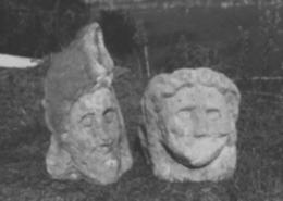
Mithras and Demeter
Up to 30 AD the Greek traders who operated the eastern trade routes for Mediterranean markets, needed at least three years for a round voyage to India and back, following the tortuous coastline of Asia, as Alexander the Great had done when he returned to Babylon from his expedition to India.
About 30 AD an Alexandrian skipper named Hippalus, as we have seen, discovered how to use the monsoon winds to cross the Indian Ocean in the space of only three months. He returned from India in less that a year, thereby shortening the trade routes. Within a year up to 100 Greek ships were sailing for India. They returned with silks, spices and precious stones in return for Roman gold.
By this time Greek mariners possessed a clearer picture of the earth's shape, and the concepts of latitude and longitude. In 239 BC Eratosthenese had calculated the circumference of the earth as being about 28,000 miles, an error of excess of only 13%. Thus the degree of latitude was erroneously placed at 69 nautical miles, instead of 60, the correct value. yet this error was not enough to prevent vessels making successful ocean crossings, arriving at a pre-arranged location.
Mariners calculated longitude by dead reckoning, and this method continued until the dawn of European voyages in the 15th century. Lacking the magnetic compass, the stars, sun and moon, when visible, provided bearings which could not be taken in cloudy conditions. Astronomical observations of the Greek sailors were set into an ancient form of astrolabe which, together with the cross staff {used for calculating the elevation of the midday sun or other heavenly bodies at the time of their meridional passage} gave a correct latitudinal reading.
By 100 BC an unknown Greek inventor had devised a mechanical computer {See Chapter Seven In my Book "Pyramids in the Pacific Out Now} which became indispensable to mariners, for it performed the operations of an astrolabe by the cranking of bronze gears and dials. The remains of one such instrument now rest in the National Museum of Athens, recovered by divers from an ancient Greek wreck.
With such advanced instrumentation and large ocean-going vessels, there would have been no barrier to southward exploration into Australian waters by the Greeks. There can be no doubt that maritime and geographical knowledge in the ancient world was far more advanced than conservative historians are willing to admit. Relics suggesting ancient Greek contacts with Australia have been turning up for many years over a wide area of the continent.
|
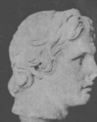
Alexander The Great